Lake Oswego to Beverly Beach SP, Depoe Bay, OR
Wednesday, October 4, 2006 … 115 Camper Miles – Total 8,921
Overcast, low 60s, light showers, cleared toward evening
On our way again! We did some shopping in Lake Oswego before heading for the Oregon Coast. It’s the northwest and we notice drive-through espresso and coffee vendors everywhere. This section of the coast, specifically OR-101, is very touristy. There are souvenir and junk shops, hotels and restaurants dotting the road. It seems to be Oregon’s version of the New Jersey shore. Unlike most of the NJ shore, however, the shoreline is rugged and beautiful. There is often fog near shore making for a mystical appearance.

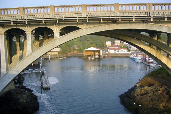
We stopped for the night at the Beverly Beach SP campground. After setting up, we drove into the town of Depoe Bay to check out their claim to be the Worlds Smallest Navigable Harbor. Indeed it is small, and even though the entrance is narrow and covered by a high bridge, it appears to be navigable. Surrounded by high rocks, it also seems snug and secure.
For supper, we had a salad and Mrs. Leeper’s Lasagna, a gluten-free lasagna-in-a-pot kit meal. (For Sandy’s celiac friends, it was pretty tasty!)
Beverly Beach SP to Jessie Honeyman Memorial SP, Florence, OR
Thursday, October 5, 2006 … 77 Camper Miles – Total 8,998
Overcast, high 50s, cleared late pm
This was a day of lighthouses, beaches and tide pools.
First on the list was Yaquina Head Lighthouse. It is situated next to a beach of volcanic rock. You can easily discern the old lava flows that extend out into the water and that form the beach. This is a rock beach. All the rocks are about the same size and all are black, formed from the same lava flows. It was neat that the rocks rattled as each wave crashed into the beach, then retreated.
In the town of Newport we drove through the Old Town area, known for it’s surviving collection of little Victorian beach houses. Since the day was rather chilly, breezy and raw, we decided to indulge in lunch at the cozy Café Stephanie. Happily, it happened that the chef prepares a variety of excellent, crustless quiches that Sandy could have to eat! Yum! At Cape Perpetua we walked the overlook trail, played around in the pretty tide pools and admired Heceta Head Lighthouse.

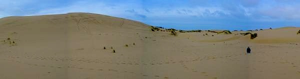
It is in this area of the coast that the Oregon Dunes begin. The huge coastal dunes run for many miles. Many of them are open to people to run dune buggies and bikes and ATVs modified to perform in the sand. Judging by the number of access areas, availability of rental units and the size of the parking lots, it appears to be a very popular pass-time. We camped at the campground in Jessie Honeyman Memorial Campground SP. Later in the afternoon, we drove out to the dunes and saw sand buggies and bikes playing around in the dunes.
Jessie Honeyman Memorial SP to Prospect RV Park, Prospect, OR
Friday, October 6, 2006 … 251 Camper Miles – Total 9,249
Heavy overcast and light rain, clearing in pm, low 60s
Another day, another lighthouse? This day started out with a very special one. The Umpqua Lighthouse, in the state park by the same name, has a very special light and we decided to take a tour. For aficionados of lights, this one packs a very rare, 1st order, Fresnel, rotating lens. It first flashes white followed by two red flashes. The docent, a retired navy guy, was extremely knowledgeable and gave an excellent tour. Visitors can even climb up inside the lens for a beautiful, if disorienting, close-up look at its construction.

Later, we walked the John Dellenback Dunes Trail out to some dunes that are not open to motorized vehicles. They ARE huge. Most of the trail is through woods and is easy walking. However, the portion in the sand is tough going, indeed!

Paved highways came late to this area because it was so rugged and remote. In fact, defending the coast during the time of war was the impetus to finally build real roads. There are lots of inlets that needed crossing and this coast is home to a series of beautiful, art deco bridges that were designed by a guy named McCullough. Although the designs differ depending on the need for a particular bridge, many are embellished with his trademark Egyptian-style obelisks that have been retained even in cases where the bridge had to be rebuilt.
It was time to head toward our next destination, Crater Lake NP. We followed OR-138. Beyond the town of Glide, this scenic highway follows the North Umqua River. It is a beautiful drive. Crater Lake campgrounds were already closed for the season. Also, we wanted to have electricity because we’d been using power for the heater fan. We ended up choosing to stay at Prospect RV Park. Owners, Pam and Jim, are nice folks and full-time RVers. They decided to build their own RV park the way they thought one should be built, with lots of shade and plenty of grassy space between sites. It’s a nice place.
When she checked us in, Pam took the time to acquaint us with the area attractions and even giving us trail maps for the area that she’d created herself. She also made recommendations on how best to visit Crater Lake and who had the best pizza in “town”. (There really weren’t any choices about the pizza.)
We made a chicken & veggie stir-fry for dinner.