Escalante to Boulder Mountain, UT
Thursday, August 3, 2006 … 57 Camper Miles – Total 4,685
Rain showers early am, low 90s, cloudy late pm
We awoke to rain this morning, so Bill read while Sandy took the chance to sleep in. After breakfast, we headed east, again, continuing along Rt 12 to Boulder. This small town is stunning, nestled among sandstone mountains along a lush, irrigated valley.

A bit further along we came to Calf Creek Canyon and hiked the six-mile round trip trail we’d heard about. It leads to an unlikely waterfall at the end of the canyon. It turned out that, although the trail was fairly level, much of it was deep sand, so the going was a bit tiring. We were encouraged, along the way, by the sights of two granary ruins, high among the cliffs, and a trio of huge shield-style petroglyphs. Finally, we were rewarded with the beautiful, 126-foot tall waterfall at the canyon’s end. It fell into a large, deep pool in which some other hikers were swimming. We didn’t have suitable clothing but Sandy did, at least, go wading.

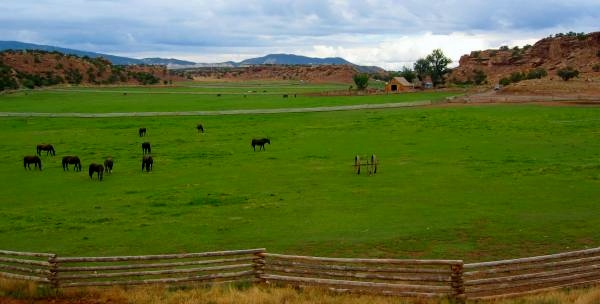
The day was hot, exceeding 90 degrees during our hike. After leaving Calf Creek Canyon, though, we began to gain altitude and by the time we reached 9,600 feet the temperature had dropped to only 64 degrees. We decided we liked the cool weather, so we set up camp at the Singletree Campground in Dixie National Forest on Boulder Mountain, still high in the mountains.


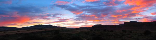
We relaxed much of the rest of the afternoon, finally making beef teriyaki for dinner. After cleaning up, we watched the sunset illuminate the distant hills. On the way back to the campsite we stopped to visit with some other campers around their campfire. That night the moon, shining bright through a camper window, reminded Sandy of sleeping under the forward hatch aboard our sailboat, Whistwind. It’s one of the few times we’ve even thought about sailing on this trip.

Boulder Mountain to Torrey, UT
Friday, August 4, 2006 … 9 Camper Miles – Total 4,694
Light showers, overcast all day, heavier rain in afternoon, cool temps
We had a relaxed breakfast and took off by 10:00 for nearby Capitol Reef National Park. Bill wanted to be able to do some e-mail and to write during the next couple of days, so we took a campsite at Thousand Lakes RV Park in Torrey, just a couple of miles from the park. This was a nice RV park with low rates, very good facilities, a pool and WiFi. (The local general store also had a cappuccino machine!)
Bill spent much of the day writing while Sandy did a few loads of wash and cleaned the camper interior. Had several hours of rain today, so it was a good time to be doing “chores”. We grilled some chicken sausage for dinner and served it with zucchini sautéed with garlic and sun-dried tomatoes.
Torrey
Saturday, August 5, 2006 … 0 Camper Miles – Total 4,694
Low 50s in camper in morning, but warmed up to high 90 and mostly sunny in afternoon
Bill got up early and wrote in morning. Then, while he had his usual breakfast of cold cereal and a banana, Sandy took the time to treat herself to a batch of fresh blueberry pancakes.
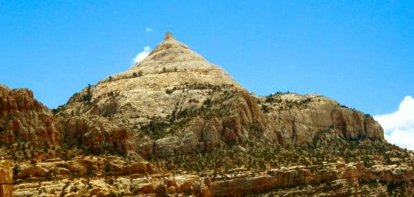
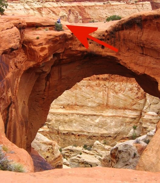
This was our day to visit Capitol Reef National Park, so we drove to the Visitor Center and sought advice on the trails we should do. (Capitol Reef is so named because the white rock domes of the area reminded early travelers of domes on government buildings and because pioneers were often ex-seamen who referred to any impediment to travel as a reef.) We headed down the scenic drive and, first, turned back the gravel road leading into Grand Wash. The road ends at a trailhead for Cassidy Arch. (The arch is named for Butch Cassidy who was said to have had a hideout in the area.) We hiked this 1¾ mile, 950 foot climb, to the top of the arch. Along the way we were rewarded with some great overviews and a prolonged encounter with four bighorn sheep. We’d not seen any bighorns before and it was quite a thrill. Finally, we got to the top of the arch. What a view! We even took photos of each other standing on top of the arch.

Returning down the trail to the car, we continued on the scenic drive and headed back another dirt track into Capitol Gorge. At the trailhead, there, we took the path into the canyon to see the Pioneer Register. This is where many early travelers recorded their passages through the reef by scratching their names and dates into the sandstone rock walls … “modern” day petroglyphs? Well, “historic” etchings, anyway.

Afternoon was waning and we had a mission. We hurried back toward the Visitor Center to stop at the Gifford House before they closed at 4:00. Of course, the sun was getting lower in the sky making the colors stand out on the west-facing reef. So we stopped many times, between moments of driving too fast, to take lots of pictures. We made it just in time. The Gifford House is a restored Mormon settler home and, today, serves as a small museum and a sales outlet for homemade ice cream. The ice cream is locally made using fruit from some of the original orchards planted by Mormon settlers. We felt that we’d earned a generous helping of that ice cream during the day’s hikes! We also purchased some canned goodies made by local residents.

After downing our ice cream, we stopped at two of the old orchards to pick both apples and peaches to take with us. We also stopped at some early Fremont petroglyph panels (next to Fremont River, of course) and visited the historic Fruita School where Mormon settler children got their learnin’.
Dinner was a taco salad using the leftover chili from a few nights ago. Dinner was topped off by a beautiful sunset. What more can we ask?

Torrey to Fruita, CO
Sunday, August 6, 2006 … 266 Camper Miles – Total 4,960
Chilly and breezy morning, but warmed up to high 90s during day’s drive
By 9:30 we were on our way. The sky was bright blue with puffy clouds. We’ve had exceptionally clear air the last few days which really enhances the views. Today’s main drive would follow Rt-24 through the San Raphael Desert. Driving through the east side of the Reef, the scenery began as white rock formations through the balance of the park. Then it abruptly turned to a desolate-looking desert of grey, volcanic-looking sand dunes and flat, brush-covered flatlands. We stopped, for a bit, to watch some dirt bikers jumping the tops of some dunes. As we drove on, the grey gradually turned to tan and we were at I-70 before we knew it. Then, we turned south after about 30 miles, and headed for Moab.


We wanted to look at the Kane Creek rock art that we had to skip on our last visit. We found the Moonflower Canyon panels, which have been badly defaced, and went on to the “Birthing Scene” rock art panels farther down the river. This is actually several panels on a single rock just off a dirt road a couple of miles back a side canyon. We dropped the camper at a turnout and went up the dirt road without it. Our trouble was rewarded with some exceptional rock art. On the way back out to pick up our camper, we noticed several rental Jeeps on the other side of the canyon, trying out their 4WD skills. We could also see some mountain bikers plying their craft among the rocks. These kinds of activities are what Moab is all about for many visitors.

From Moab we took the drive along the Colorado River canyon back up to I-70, driving through seemingly endless red sandstone canyons. The river is mostly peaceful through this area with only a few small rapids. We didn’t quite understand the big attraction for river raft trips since it seems mostly placid here. (Are we just adrenalin junkies? We think not!)

Finally returning to I-70, we soon crossed into “Colorful Colorado” and the town of Fruita. We stopped there, at the state welcome center, to seek advice on where to camp. They directed us to the new Colorado River State Park, Fruita, just two blocks away. We took a site at the park with water and electric for two days of R&R. Some rain passed through with heavy winds, but we we were rewarded with a double rainbow! We pan-fried boneless pork chops for dinner and had them with sautéed broccoli and summer squash with onions and garlic.